Rivers and Navigation

Query II.
A NOTICE of its rivers, rivulets, and Rivers and navigation and how far they are navigable?
An inspection of a map of Virginia, will give a better idea of the geography of its rivers, than any description in writing. Their navigation may be imperfectly noted.Roanoke, so far as it lies within this state, is no where navigable, but for canoes, or light batteaux; and, even for these, in such detached parcels as to have prevented the inhabitants from availing themselves of it at all.
James River, and its waters, afford navigation as follows.
The whole of Elizabeth River, the lowest of those which run into James River, is a harbour, and would contain upwards of 300 [ 4 ]
ships. The channel is from 150 to 200 fathom wide, and at common flood tide, affords 18 feet water to Norfolk. The Strafford, a 60 gun ship, went there, lightening herself to cross the bar at Sowell's point. The Fier Rodrigue, pierced for 64 guns, and carrying 50, went there without lightening. Craney island, at the mouth of this river, commands its channel tolerably well.
Nansemond River is navigable to Sleepy hole, for vessels of 250 tons; to Suffolk, for those of 100 tons; and to Milner's, for those of 25.
Pagan Creek affords 8 or 10 feet water to Smithfeild, which admits vessels of 20 ton.
Chickahominy has at its mouth a bar, on which is only 12 feet water at common flood tide. Vessels passing that, may go 8 miles up the river; those of 10 feet draught may go four miles further, and those of six tons burthen, 20 miles further.
Appamattox may be navigated as far as Broadways, by any vessel which has crossed Harrison's bar in James river; it keeps 8 or 9 feet water a mile or two higher up to Fisher's bar, and 4 feet on that and upwards to Petersburgh, where all navigation ceases.
James River itself affords harbour for vessels of any size in Hampton Road, but not in safety through the whole winter; and [ 5 ]
there is navigable water for them as far as Mulberry island. A 40 gun ship goes to James town, and, lightening herself, may pass to Harrison's bar, on which there is only 15 feet water. Vessels of 250 tons may go to Warwick; those of 125 go to Rocket's, a mile below Richmond; from thence is about 7 feet water to Richmond; and about the center of the town, four feet and a half, where the navigation is interrupted by falls, which in a course of six miles, descend about 80 feet perpendicular: above these it is resumed in canoes and batteaux, and is prosecuted safely and advantageously to within 10 miles of the Blue ridge; and even through the Blue ridge a ton weight has been brought; and the expence would not be great, when compared with its object, to open a tolerable navigation up Jackson's river and Carpenter's creek, to within 25 miles of Howard's creek of Green briar, both of which have then water enough to float vessels into the Great Kanhaway. In some future state of population, I think it possible, that its navigation may also be made to interlock with that of the Patowmac, and through that to communicate by a short portage with the Ohio. It is to be noted, that this river is called in the maps James River, only to its confluence with the Rivanna; thence to the [ 6 ] Blue ridge it is called the Fluvanna; and thence to its source, Jackson's river. But in common speech, it is called James river to its source.

The Rivanna, a branch of James river, is navigable for canoes and batteaux to its intersection with the South West mountains, which is about 22 miles; and may easily be opened to navigation through those mountains to its fork above Charlottesville.
York River, at York town, affords the best harbour in the state for vessels of the largest size. The river there narrows to the width of a mile, and is contained within very high banks, close under which the vessels may ride. It holds 4 fathom water at high tide for 25 miles above York to the mouth of Poropotank, where the river is a mile and a half wide, and the channel only 75 fathom, and passing under a high bank. At the confluence of Pamunkey and Mattapony, it is reduced to 3 fathom depth, which continues up Pamunkey to Cumberland, where the width is 100 yards, and up Mattapony to within two miles of Frazer's ferry, where it becomes 2½ fathom deep, and holds that about five miles. Pamunkey is then capable of navigation for loaded flats to Brockman's bridge, 50 miles above Hanover town, [ 7 ]
and Mattapony to Downer's bridge, 70 miles above its mouth.
Piankatank, the little rivers making out of Mobjack bay and those of the Eastern Shore, receive only very small vessels, and these can but enter them.
Rappahanock affords 4 fathom water to Hobb's hole, and 2 fathom from thence to Fredericksburg.
Patowmac is 7½ miles wide at the mouth ; 4½ at Nomony bay; 3 at Aquia; 1½ at Hallooing point; 1¼ at Alexandria. Its soundings are, 7 fathom at the mouth; 5 at St. George's island; 4½ at Lower Matchodic ; 3 at Swan's point, and thence up to Alexandria; thence 10 feet water to the falls, which are 13 miles above Alexandria. These falls are 15 miles in length, and of very great descent, and the navigation above them for batteaux and canoes, is so much interrupted as to be little used. It is, however, used in a small degree up the Cohongoronta branch as far as Fort Cumberland, which was at the mouth of Wills's creek: and is capable, at no great expence, of being rendered very practicable. The Shenandoah branch interlocks with James river about the Blue ridge, and may perhaps in future be opened.
[ 8 ]
The Missisipi will be one of the principal channels of future commerce for the country westward of the Alleghaney. From the mouth of this river to where it receives the Ohio, is 1000 miles by water, but only 500 by land, passing through the Chickasaw country. From the mouth of the Ohio to that of the Missouri, is 230 miles by water, and 140 by land. From thence to the mouth of the Illinois river, is about 25 miles. The Missisipi, below the mouth of the Missouri, is always muddy, and abounding with sand bars, which frequently change their places. However, it carries 15 feet water to the mouth of the Ohio, to which place it is from one and a half to two miles wide, and thence to Kaskaskia from one mile to a mile and a quarter wide. Its current is so rapid, that it never can be stemmed by the force of the wind alone, acting on sails. Any vessel, however, navigated with oars, may come up at any time, and receive much aid from the wind. A batteaux passes from the mouth of Ohio to the mouth of Missisipi in three weeks, and is from two to three months getting up again. During its floods, which are periodical as those of the Nile, the largest vessels may pass down it, if their steerage can be ensured. These floods begin in April, and the river returns into its banks [ 9 ]
early in August. The inundation extends further on the western than eastern side, covering the lands in some places for 50 miles from its banks. Above the mouth of the Missouri, it becomes much such a river as the Ohio, like it clear; and gentle in its current, not quite so wide, the period of its floods nearly the same, but not rising to so great a height. The streets of the village at Cohoes are not more than 10 feet above the ordinary level of the water, and yet were never overflowed. Its bed deepens every year. Cohoes, in the memory of many people now living, was insulated by every flood of the river. What was the Eastern channel has now become a lake, 9 miles in length and one in width, into which the river at this day never flows. This river yields turtle of a peculiar kind, perch, trout, gar, pike, mullets, herrings, carp, spatula fish Atractosteus spatula, now commonly known as the Alligator Gar. of 50 lb. weight, cat fish of an hundred pounds weight, buffalo fish, Ictiobus, a common freshwater fish. and sturgeon. Alligators or crocodiles have been seen as high up as the Acansas.Arkansas. It also abounds in herons, cranes, ducks, brant, geese, and swans. Its passage is commanded by a fort established by this state, five miles below the mouth of Ohio, and ten miles above the Carolina boundary.
[ 10 ]

The Missouri, since the treaty of Paris, the Illinois and Northern branches of the Ohio since the cession to Congress, are no longer within our limits. Yet having been so heretofore, and still opening to us channels of extensive communication with the western and north-western country, they shall be noted in their order.
The Missouri is, in fact, the principal river, contributing more to the common stream than does the Missisipi, even after its junction with the Illinois. It is remarkably cold, muddy and rapid. Its overflowings are considerable. They happen during the months of June and July. Their commencement being so much later than those of the Missisipi, would induce a belief that the sources of the Missouri are northward of those of the Missisipi, unless we suppose that the cold increases again with the ascent of the land from the Missisipi westwardly. That this ascent is great, is proved by the rapidity of the river. Six miles above the mouth it is brought within the compass of a quarter of a mile's width : yet the Spanish Merchants at Pancore Pancore or Pain Court is now a part of the city of St. Louis, Missouri., or St. Louis, say they go two thousand miles up it. It heads far westward of the Rio Norte, or North River Now known as the Rio Grande.. There is, in the villages of Kaskaskia, Cohoes and St. Vincennes, no inconsiderable quantity of [ 11 ]
plate, said to have been plundered during the last war by the Indians from the churches and private houses of Santa Fé, on the North River, and brought to these villages for sale. From the mouth of Ohio to Santa Fé are forty days journey, or about 1000 miles. What is the shortest distance between the navigable waters of the Missouri, and those of the North River, or how far this is navigable above Santa Fé, I could never learn. From Santa Fé to its mouth in the Gulph of Mexico is about 1200 miles. The road from New Orleans to Mexico crosses this river at the post of Rio Norte, 800 miles below Santa Fé: and from this post to New Orleans is about 1200 miles; thus making 2000 miles between Santa Fé and New Orleans, passing down the North river, Red river and Missisipi; whereas it is 2230 through the Missouri and Missisipi. From the same post of Rio Norte, passing near the mines of La Sierra and Laiguana, which are between the North river and the river Salina to Sartilla, is 375 miles; and from thence, passing the mines of Charcas, Zaccatecas and Potosi, to the city of Mexico is 375 miles; in all, 1550 miles from Santa Fé to the city of Mexico. From New Orleans to the city of Mexico is about 1950 miles: the roads, after setting out from the Red river, near [ 12 ] Natchitoches, keeping generally parallel with the coast, and about two hundred miles from it, till it enters the city of Mexico.
The Illinois is a fine river, clear, gentle, and without rapids; insomuch that it is navigable for batteaux A kind of flat-bottomed boat, widely used in this period for navigating rivers. to its source. From thence is a portage of two miles only to the Chickago, which affords a batteau navigation of 16 miles to its entrance into lake Michigan. The Illinois, about 10 miles above its mouth, is 300 yards wide.
The Kaskaskia is 100 yards wide at its entrance into the Missisipi, and preserves that breadth to the Buffalo plains, 70 miles above. So far also it is navigable for loaded batteaux, and perhaps much further. It is not rapid.
The Ohio is the most beautiful river on earth. Its current gentle, waters clear, and bosom smooth and unbroken by rocks and rapids, a single instance only excepted.
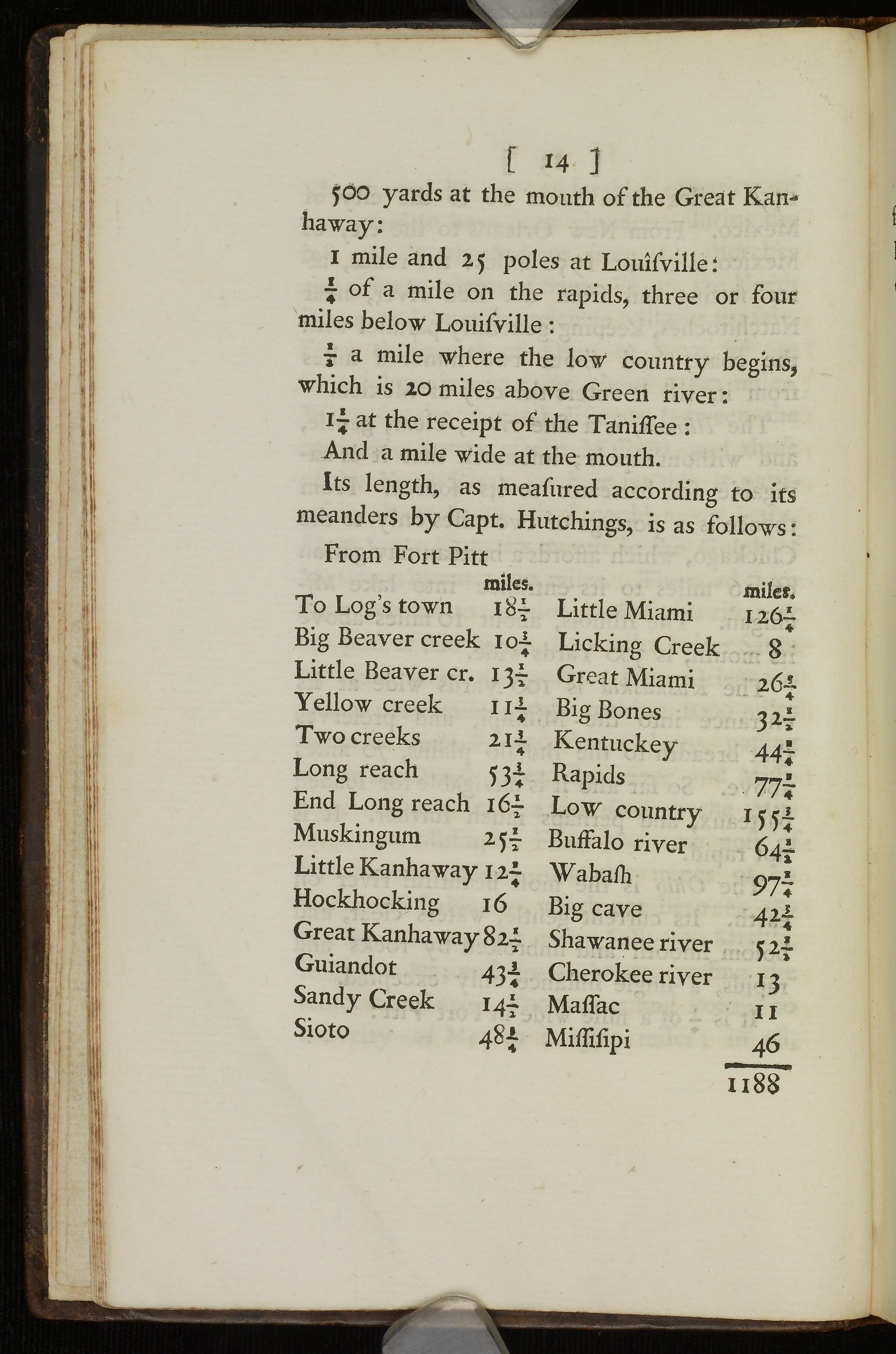
It is ¼ of a mile wide at Fort Pitt:
500 yards at the mouth of the Great Kanhaway:
1 mile and 25 poles at Louisville:
¼ of a mile on the rapids, three or four miles below Louisville:
½ a mile where the low country begins, which is 20 miles above Green river :
1¼ at the receipt of the Tanissee:
[ 13 ]
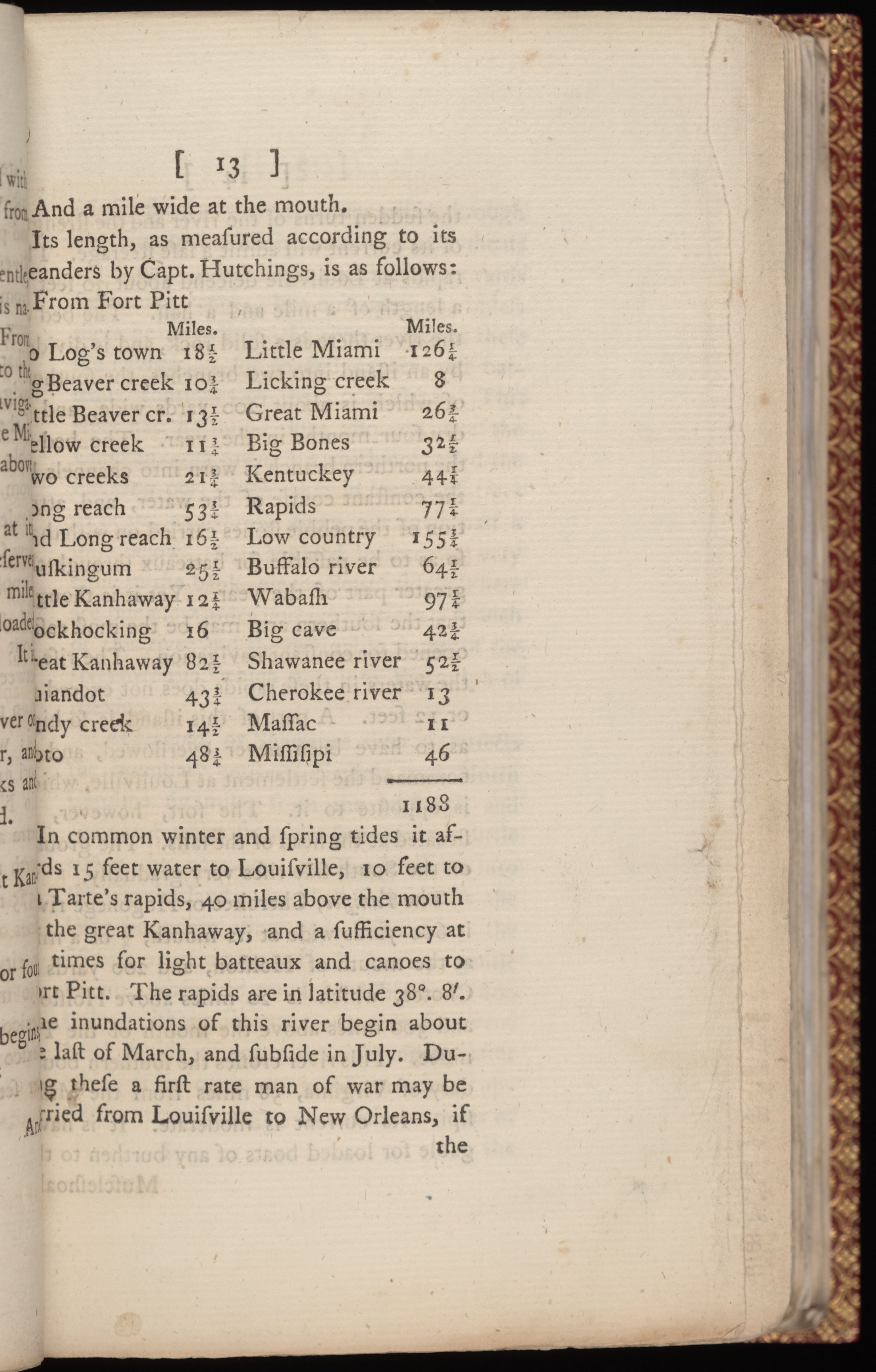
And a mile wide at the mouth. Its length, as measured according to its meanders by Capt. Hutchings, Thomas Hutchins (1730-89) was the first (and still the only) official Geographer of the United States, author of A Topographical Description of Virginia, Pennsylvania, Maryland, and North Carolina (1778), which Jefferson owned, and a History, Narrative, and Topographical Description of Louisiana and West Florida (1784). is as follows:
From Fort Pitt At the site of present-day Pittsburgh.
| Miles. | Miles. | ||
| To Log's town | 18½ | Little Miami | 126¼ |
| Big Beaver creek | 10¾ | Licking creek | 8 |
| Little Beaver cr. | 13½ | Great Miami | 26¾ |
| Yellow creek | 11¾ | Big Bones | 32½ |
| Two creeks | 21¾ | Kentuckey | 44¼ |
| Long reach | 53¾ | Rapids | 77¼ |
| End Long reach | 16½ | Low country | 155¾ |
| Muskingum | 25½ | Buffalo river | 64½ |
| Little Kanhaway | 12¼ | Wabash | 97¼ |
| Hockhocking | 16 | Big cave | 42¾ |
| Great Kanhaway | 82½ | Shawanee river | 52½ |
| Guiandot | 43¾ | Cherokee river | 13 |
| Sandy creek | 14½ | Massac | 11 |
| Sioto | 48¾ | Missisipi | 46 |
| 1188 |
In common winter and spring tides it affords 15 feet water to Louisville, 10 feet to La Tarte's rapids, 40 miles above the mouth of the great Kanhaway, and a sufficiency at all times for light batteaux and canoes to Fort Pitt. The rapids are in latitude 38°. 8'. The inundations of this river begin about the last of March, and subside in July. During these a first rate man of war may be carried from Louisville to New Orleans, if [ 14 ]
the sudden turns of the river and the strength of its current will admit a safe steerage. The rapids at Louisville descend about 30 feet in a length of a mile and a half. The bed of the river there is a solid rock, and is divided by an island into two branches, the southern of which is about 200 yards wide, and is dry four months in the year. The bed of the northern branch is worn into channels by the constant course of the water, and attrition of the pebble stones carried on with that, so as to be passable for batteaux through the greater part of the year. Yet it is thought that the southern arm may be the most easily opened for constant navigation. The rise of the waters in these rapids does not exceed 10 or 12 feet. A part of this island is so high as to have been never overflowed, and to command the settlement at Louisville, which is opposite to it. The fort, however, is situated at the head of the falls. The ground on the South side rises very gradually.
The Tanissee Tennessee, Cherokee or Hogohege river is 600 yards wide at its mouth, ¼ of a mile at the mouth of Holston, and 200 yards at Chotee, which is 20 miles above Holston, and 300 miles above the mouth of the Tanissee. This river crosses the southern boundary of Virginia, 58 miles from the Missisipi. Its current is moderate. It is navigable for loaded boats of any burthen to the [ 15 ]
Muscleshoals, where the river passes through the Cumberland mountain. These shoals are 6 or 8 miles long, passable downwards for loaded canoes, but not upwards, unless there be a swell in the river. Above these the navigation for loaded canoes and batteaux continues to the Long island. This river has its inundations also. Above the Chickamogga towns is a whirlpool called the Sucking-pot, which takes in trunks of trees or boats, and throws them out again half a mile below. It is avoided by keeping very close to the bank, on the South side. There are but a few miles portage between a branch of this river and the navigable waters of the river Mobile, which runs into the gulph of Mexico.
Cumberland, or Shawanee river, intersects the boundary between Virginia and North Carolina 67 miles from the Missisipi, and again 198 miles from the same river, a little above the entrance of Obey's river into the Cumberland. Its clear fork crosses the same boundary about 300 miles from the Missisipi. Cumberland is a very gentle stream, navigable for loaded batteaux 800 miles, without interruption; then intervene some rapids of 15 miles in length, after which it is again navigable 70 miles upwards, which brings you within 10 miles of [ 16 ]
the Cumberland mountains. It is about 126 yards wide through its whole course, from the head of its navigation to its mouth.

The Wabash is a very beautiful river, 400 yards wide at the mouth, and 300 at St. Vincennes, which is a post 100 miles above the mouth, in a direct line. Within this space there are two small rapids, which give very little obstruction to the navigation. It is 400 yards wide at the mouth, and navigable 30 leagues upwards for canoes and small boats. From the mouth of Maple river to that of Eel river is about 80 miles in a direct line, the river continuing navigable, and from one to two hundred yards in width. The Eel river is 150 yards wide, and affords at all times navigation for periaguas, to within 18 miles of the Miami of the lake. The Wabash, from the mouth of Eel river to Little river, a distance of 50 miles direct, is interrupted with frequent rapids and shoals, which obstruct the navigation, except in a swell. Little river affords navigation during a swell to within 3 miles of the Miami, which thence affords a similar navigation into lake Erié, 100 miles distant in a direct line. The Wabash overflows periodically in correspondence with the Ohio, and in some places two leagues from its banks.
[ 17 ]
Green River is navigable for loaded batteaux at all times 50 miles upwards; but it is then interrupted by impassable rapids, above which the navigation again commences, and continues good 30 or 40 miles to the mouth of Barren river.
Kentucky river is 90 yards wide at the mouth, and also at Boonsborough, 80 miles above. It affords a navigation for loaded batteaux 180 miles in a direct line, in the winter tides.
The Great Miami of the Ohio, is 200 yards wide at the mouth. At the Piccawee towns, 75 miles above, it is reduced to 30 yards; it is, nevertheless, navigable for loaded canoes 50 miles above these towns. The portage from its western branch into the Miami of Lake Erié, is 5 miles; that from its eastern branch into Sandusky river, is of 9 miles.
Salt river is at all times navigable for loaded batteaux 70 or 80 miles. It is 80 yards wide at its mouth, and keeps that width to its fork, 25 miles above.
The Little Miami of the Ohio, is 60 or 70 yards wide at its mouth, 60 miles to its source, and affords no navigation.
The Sioto is 250 yards wide at its mouth, which is in latitude 38°. 22'. and at the Saltlick towns, 200 miles above the mouth, [ 18 ]
it is yet 100 yards wide. To these towns it is navigable for loaded batteaux, and its eastern branch affords navigation almost to its source.
Great Sandy river is about sixty yards wide, and navigable sixty miles for loaded batteaux.
Guiandot is about the width of the river last mentioned, but is more rapid. It may be navigated by canoes sixty miles.
The Great Kanhaway is a river of considerable note for the fertility of its lands, and still more, as leading towards the headwaters of James river. Nevertheless, it is doubtful whether its great and numerous rapids will admit a navigation, but at an expence to which it will require ages to render its inhabitants equal. The great obstacles begin at what are called the great falls, 90 miles above the mouth, below which are only five or six rapids, and these passable, with some difficulty, even at low water. From the falls to the mouth of Greenbriar is 100 miles, and thence to the lead mines 120. It is 280 yards wide at its mouth.
Hock-hocking is 80 yards wide at its mouth, and yields navigation for loaded batteaux to the Press-place, 60 miles above its mouth.
The Little Kanhaway is 150 yards wide at the mouth. It yields a navigation of 10 miles only. Perhaps its northern branch, [ 19 ]
called Junius's creek, which interlocks with the western of Monongahela, may one day admit a shorter passage from the latter into the Ohio.
The Muskingum is 280 yards wide at its mouth, and 200 yards at the lower Indian towns, 150 miles upwards. It is navigable for small batteaux to within one mile of a navigable part of Cayahoga river, which runs into lake Erié.
At Fort Pitt the river Ohio loses its name, branching into the Monongahela and Alleghaney.
The Monongahela is 400 yards wide at its mouth. From thence is 12 or 15 miles to the mouth of Yohoganey, where it is 300 yards wide. Thence to Redstone by water is 50 miles, by land 30. Then to the mouth of Cheat river by water 40 miles, by land 28, the width continuing at 300 yards, and the navigation good for boats. Thence the width is about 200 yards to the western fork, 50 miles higher, and the navigation frequently interrupted by rapids; which however with a swell of two or three feet become very passable for boats. It then admits light boats, except in dry seasons, 65 miles further to the head of Tygarts valley, presenting only some small rapids and falls of one or two feet perpendicular, and lessening in its width to 20 [ 20 ]
yards. The Western fork is navigable in the winter 10 or 15 miles towards the northern of the Little Kanhaway, and will admit a good waggon road to it. The Yohoganey is the principal branch of this river. It passes through the Laurel mountain, about 30 miles from its mouth; is so far from 300 to 150 yards wide, and the navigation much obstructed in dry weather by rapids and shoals. In its passage through the mountain it makes very great falls, admitting no navigation for ten miles to the Turkey foot. Thence to the great crossing, about 20 miles, it is again navigable, except in dry seasons, and at this place is 200 yards wide. The sources of this river are divided from those of the Patowmac by the Alleghaney mountain. From the falls, where it intersects the Laurel mountain, to Fort Cumberland, the head of the navigation on the Patowmac, is 40 miles of very mountainous road. Wills's creek, at the mouth of which was Fort Cumberland, is 30 or 40 yards wide, but affords no navigation as yet. Cheat river, another considerable branch of the Monongahela, is 200 yards wide at its mouth, and 100 yards at the Dunkard's settlement, 50 miles higher. It is navigable for boats, except in dry seasons. The boundary between Virginia and [ 21 ] Pennsylvania crosses it about three or four miles above its mouth.

The Alleghaney river, with a slight swell, affords navigation for light batteaux to Venango, at the mouth of French creek, where it is 200 yards wide; and it is practised even to Le Boeuf, from whence there is a portage of 15 miles to Presque Isle on Lake Erié.
The country watered by the Missisipi and its eastern branches, constitutes five-eighths of the United States, two of which five-eighths are occupied by the Ohio and its waters; the residuary streams which run into the Gulph of Mexico, the Atlantic, and the St. Laurence water, the remaining three-eighths.
Before we quit the subject of the western waters, we will take a view of their principal connections with the Atlantic. These are three; the Hudson's river, the Patowmac, and the Missisipi itself. Down the last will pass all heavy commodities. But the navigation through the Gulph of Mexico is so dangerous, and that up the Missisipi so difficult and tedious, that it is thought probable that European merchandize will not return through that channel. It is most likely that flour, timber, and other heavy articles will be floated on rafts, which will themselves be an article for sale as well as their loading, the [ 22 ]
navigators returning by land or in light batteaux. There will therefore be a competition between the Hudson and Patowmac rivers for the residue of the commerce of all the country westward of Lake Erié, on the waters of the lakes, of the Ohio, and upper parts of the Missisipi. To go to New-York, that part of the trade which comes from the lakes or their waters must first be brought into Lake Erié. Between Lake Superior and its waters and Huron are the rapids of St. Mary, which will permit boats to pass, but not larger vessels. Lakes Huron and Michigan afford communication with Lake Erié by vessels of 8 feet draught. That part of the trade which comes from the waters of the Missisipi must pass from them through some portage into the waters of the lakes. The portage from the Illinois river into a water of Michigan is of one mile only. From the Wabash, Miami, Muskingum, or Alleghaney, are portages into the waters of Lake Erié, of from one to fifteen miles. When the commodities are brought into, and have passed through Lake Erié, there is between that and Ontario an interruption by the falls of Niagara, where the portage is of 8 miles; and between Ontario and the Hudson's river are portages at the falls of Onondago, a little above Oswego, of a quarter of a mile; from [ 23 ] Wood creek to the Mohawks river two miles; at the little falls of the Mohawks river half a mile, and from Schenectady to Albany 16 miles. Besides the increase of expence occasioned by frequent change of carriage, there is an increased risk of pillage produced by committing merchandize to a greater number of hands successively. The Patowmac offers itself under the following circumstances. For the trade of the lakes and their waters westward of Lake Erié, when it shall have entered that lake, it must coast along its southern shore, on account of the number and excellence of its harbours, the northern, though shortest, having few harbours, and these unsafe. Having reached Cayahoga, to proceed on to New-York it will have 825 miles and five portages: whereas it is but 425 miles to Alexandria, its emporium on the Patowmac, if it turns into the Cayahoga, and passes through that, Bigbeaver, Ohio, Yohoganey, (or Monongalia and Cheat) and Patowmac, and there are but two portages; the first of which between Cayahoga and Beaver may be removed by uniting the sources of these waters, which are lakes in the neighbourhood of each other, and in a champaign country; the other from the waters of Ohio to Patowmac will be from 15 to 40 miles, according to the trouble which shall be taken to approach the two [ 24 ] navigations. For the trade of the Ohio, or that which shall come into it from its own waters or the Missisipi, it is nearer through the Patowmac to Alexandria than to New-York by 580 miles, and it is interrupted by one portage only. There is another circumstance of difference too. The lakes themselves never freeze, but the communications between them freeze, and the Hudson's river is itself shut up by the ice three months in the year; whereas the channel to the Chesapeak leads directly into a warmer climate. The southern parts of it very rarely freeze at all, and whenever the northern do, it is so near the sources of the rivers, that the frequent floods to which they are there liable break up the ice immediately, so that vessels may pass through the whole winter, subject only to accidental and short delays. Add to all this, that in case of a war with our neighbours the Anglo-Americans or the Indians, the route to New-York becomes a frontier through almost its whole length, and all commerce through it ceases from that moment.—But the channel to New-York is already known to practice; whereas the upper waters of the Ohio and the Patowmac, and the great falls of the latter, are yet to be cleared of their fixed obstructions (I).