Mountains
Query IV.
A NOTICE of its Mountains?
For the particular geography of our mountains I must refer to Fry and Jefferson's map Joshua Fry (1699-1754) and Peter Jefferson (1708-57), Thomas Jefferson's father, drew a well-known map of Virginia and Maryland in 1751. of Virginia; and to Evans's Lewis Evans (c. 1700-56) was a cartographer who published two important maps: A Map of Pennsylvania, New York, and the Three Delaware Counties (1749) and A General Map of the Middle British Colonies in America, which was published with a pamphlet of analysis entitled Geographical, Historical, Political, Philosophical and Mechanical Essays (1755). analysis of his map of America for a more philosophical view of them than is to be found in any other work. It is worthy notice, that our mountains are not solitary and scattered confusedly over the face of the country; but that they commence at about 150 miles from the sea-coast, are disposed in ridges one behind another, running nearly parallel with the sea-coast, though rather approaching it as they advance north-eastwardly. To the south-west, as the tract of country between the sea-coast and the Mississipi becomes narrower, the mountains converge into a single [ 26 ]
ridge, which, as it approaches the Gulph of Mexico, subsides into plain country, and gives rise to some of the waters of that Gulph, and particularly to a river called the Apalachicola, probably from the Apalachies, an Indian nation formerly residing on it. Hence the mountains giving rise to that river, and seen from its various parts, were called the Apalachian mountains, being in fact the end or termination only of the great ridges passing through the continent. European geographers however extended the name northwardly as far as the mountains extended; some giving it, after their separation into different ridges, to the Blue ridge, others to the North mountain, others to the Alleghaney, others to the Laurel ridge, as may be seen in their different maps. But the fact I believe is, that none of these ridges were ever known by that name to the inhabitants, either native or emigrant, but as they saw them so called in European maps. In the same direction generally are the veins of lime-stone, coal and other minerals hitherto discovered: and so range the falls of our great rivers. But the courses of the great rivers are at right angles with these. James and Patowmac penetrate through all the ridges of mountains eastward of the Alleghaney; that is broken by no watercourse. [ 27 ] It is in fact the spine of the country between the Atlantic on one side, and the Missisipi and St. Laurence on the other. The passage of the Patowmac This is present-day Harper's Ferry, West Virginia. through the Blue ridge is perhaps one of the most stupendous scenes in nature. You stand on a very high point of land. On your right comes up the Shenandoah, having ranged along the foot of the mountain an hundred miles to seek a vent. On your left approaches the Patowmac, in quest of a passage also. In the moment of their junction they rush together against the mountain, rend it asunder, and pass off to the sea. The first glance of this scene hurries our senses into the opinion, that this earth has been created in time, that the mountains were formed first, that the rivers began to flow afterwards, that in this place particularly they have been dammed up by the Blue ridge of mountains, and have formed an ocean which filled the whole valley; that continuing to rise they have at length broken over at this spot, and have torn the mountain down from its summit to its base. The piles of rock on each hand, but particularly on the Shenandoah, the evident marks of their disrupture and avulsion from their beds by the most powerful agents of nature, corroborate the impression. But the distant finishing which nature has given to the [ 28 ] picture is of a very different character. It is a true contrast to the fore-ground. It is as placid and delightful, as that is wild and tremendous. For the mountain being cloven asunder, she presents to your eye, through the cleft, a small catch of smooth blue horizon, at an infinite distance in the plain country, inviting you, as it were, from the riot and tumult roaring around, to pass through the breach and participate of the calm below. Here the eye ultimately composes itself; and that way too the road happens actually to lead. You cross the Patowmac above the junction, pass along its side through the base of the mountain for three miles, its terrible precipices hanging in fragments over you, and within about 20 miles reach Frederic town and the fine country round that. This scene is worth a voyage across the Atlantic. Yet here, as in the neighbourhood of the natural bridge Natural Bridge, a striking geological formation in Rockbridge County, Virginia. Jefferson had purchased it in 1774. See also Jefferson's longer discussion, beginning on page 35., are people who have passed their lives within half a dozen miles, and have never been to survey these monuments of a war between rivers and mountains,which must have shaken the earth itself to its center. (2). — The height of our mountains has not yet been estimated with any degree of exactness. The Alleghaney being the great ridge which divides the waters of the Atlantic from those [ Tip-in 12, Page 1 ]


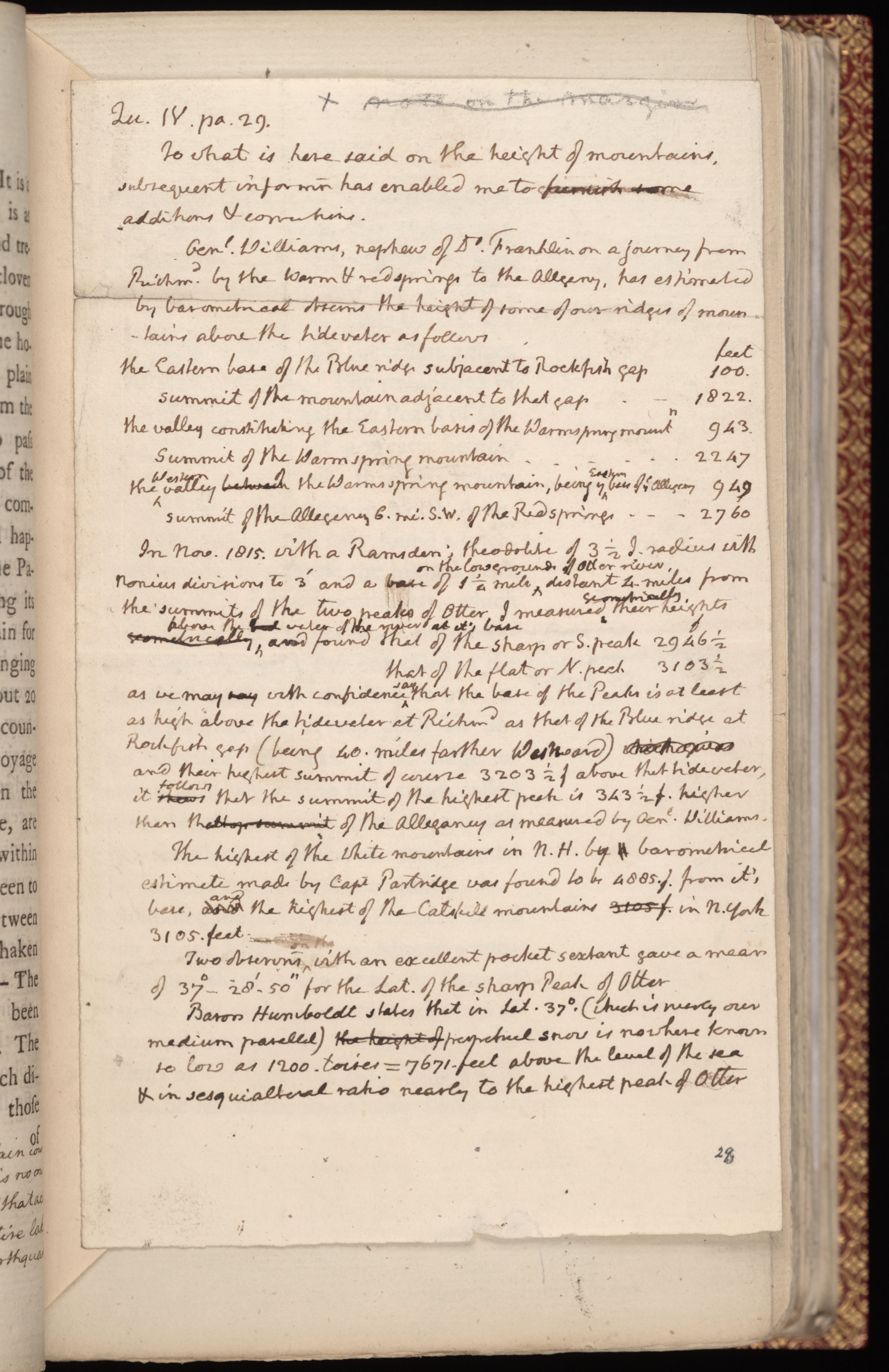
To what is here said on the height of mountains, subsequent information has enabled me to furnish some additions & corrections.
Genl. Williams, nephew of Dr. Franklin on a journey from Richm.d by the warm and red Springs to the Alleganey, has estimated by barometrical observns the height of some of our ridges of mountains above the tidewater as follows:
| feet | |
| the Eastern base of the Blue ridge subjacent to Rockfish Gap | 100. |
| summit of the mountain adjacent to that gap | 1822. |
| the valley constituting the Eastern basis of the Warmspring mountn | 943 |
| Summit of the Warmspring mountain | 2247 |
| the Western valley of the Warmspring mountain, being the Eastern base of the Alleganey | 949 |
| summit of the Alleganey 6. mi. S.W. of the Red springs | 2760 |
In Nov. 1815. with a Ramsden’s theodolite of 3½ I. radius, with nonius divisions to
3′ and a base of 1¼ mile on the low grounds of Otter River, distant 4 miles from the
summits of the two peaks of Otter, I measured geometrically their heights above the
water of the river at it's base, and found that of the sharp or S. peak 2946½
that of the flat or N. peak 3103½
as we may with confidence say that the base of the Peaks is at least as high above
the tidewater at Richmd as that of the Blue Ridge at Rockfish gap (being 40. miles farther Westward) and
their highest summit of course 3203½ f above that tidewater, it follows that the summit
of the highest peak is 343½ f. higher than that of the Alleganey, as measured by Genl. Williams.
The highest of the White Mountains in N.H. by barometrical estimate made by Captain Partridge, was found to be 4885. f. from it's base, and the highest of the Catskill mountains in N. York 3105. feet.
Two observns with an excellent pocket sextant gave a mean of 37°-28'-50" for the lat. of the sharp Peak of Otter.
Baron Humboldt states that in lat. 37°. (which is nearly over medium parallel) perpetual snow is nowhere known so low as 1200. toises = 7671. feet above the level of the sea & in sesquialtoral ratio nearly to the highest peak of Otter.
[ 29 ]
of the Missisipi, its summit is doubtless more elevated above the ocean than that of any other mountain. But its relative height, compared with the base on which it stands, is not so great as that of some others, the country rising behind the successive ridges like the steps of stairs. The mountains of the Blue ridge, and of these the Peaks of OtterA formation of two mountains in Bedford County, Virginia., are thought to be of a greater height, measured from their base, than any others in our country, and perhaps in North America. From data, which may found a tolerable conjecture, we suppose the highest peak to be about 4000 feet perpendicular, which is not a fifth part of the height of the mountains of South America, nor one third of the height which would be necessary in our latitude to preserve ice in the open air unmelted through the year. The ridge of mountains next beyond the Blue ridge, called by us the North mountain, is of the greatest extent; for which reason they were named by the Indians the Endless mountains.
A substance supposed to be Pumice, found floating on the Missisipi, has induced a conjecture, that there is a volcano on some of its waters: and as these are mostly known to their sources, except the Missouri, our expectations of verifying the conjecture would of course be led to the mountains which [ 30 ]
divide the waters of the Mexican Gulph from those of the South Sea; but no volcano having ever yet been known at such a distance from the sea, we must rather suppose that this floating substance has been erroneously deemed Pumice.